Projection Type
Represents a map projection: the mathematical transformation used to represent locations on the Earth’s curved surface as coordinates on a flat plane. Every projection is tied to a coordinate reference system (CRS), which combines a datum, an ellipsoid (or sphere) model of the Earth, the projection method itself, and a unit of measurement. The projection assigned to a map determines how its coordinates are interpreted and how it aligns with other spatial data.
Projections can be defined in one of four ways:
- Using the predefined options (UTM, Geodetic, etc.) — a curated list of common projections that can be selected directly, without specifying any further parameters.
- Using a WKT specification — a complete, self-contained description of the CRS.
- Using an EPSG code — a numeric identifier looked up in the EPSG Geodetic Parameter Registry.
- Using a Proj4 specification — a compact, parameter-based string.
WKT specifications must follow the WKT standard syntax. A WKT description fully defines the CRS — datum, spheroid, prime meridian, angular/linear units, projection method and its parameters — which makes it the most explicit and portable of the four ways to specify a projection. See the example below:
PROJCS["SUTM21",
    GEOGCS["SOUTH AMERICAN 1969",
        DATUM["SAD69",
            SPHEROID["INT67",6378160,298.25]],
        PRIMEM["Greenwich",0],
        UNIT["degree",0.0174532925199433]],
    PROJECTION["Transverse_Mercator"],
    PARAMETER["latitude_of_origin",0],
    PARAMETER["central_meridian",-57],
    PARAMETER["scale_factor",0.9996],
    PARAMETER["false_easting",500000],
    PARAMETER["false_northing",10000000],
    UNIT["Meter",1]]
The Proj4 syntax must also follow the Proj4 specification syntax. Rather than the nested structure of WKT, Proj4 represents a CRS as a list of +key=value flags, which tends to be more compact and faster to write by hand. Example:
+proj=latlong +ellps=GRS80 +towgs84=-199.87,74.79,246.62
GUI Editor
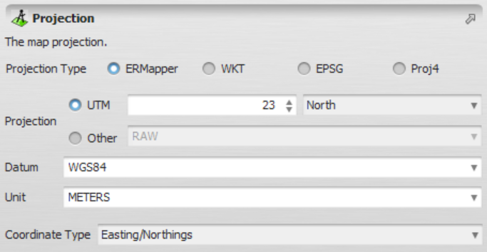
The projection editor lets you select and configure a projection using any of the four definition methods described above.
EGO Script
A constant representing a projection in an EGO Script can be defined in four different ways:
Using ERMapper parameters
This form specifies the coordinate type together with three keywords — projection, datum and unit — following the naming conventions used by ER Mapper.
[| "COORDINATE_TYPE", "ERMAPPER_PROJECTION", "ERMAPPER_DATUM", "ERMAPPER_UNIT" |]
All parameters are case-insensitive and must be surrounded by double quotes.
Example:
[| "LATLONG", "GEODETIC", "WGS84", "METERS" |]
Using a WKT (Well-Known Text) description
This form embeds a full WKT description directly in the script, giving complete control over every CRS parameter.
[| "COORDINATE_TYPE", WKT_PROJECTION |]
The syntax used to represent the WKT_PROJECTION can be found here. It is worth noting that only the COORDINATE_TYPE must be surrounded by double quotes.
Example:
[| "LATLONG",
   PROJCS["unnamed",
       GEOGCS["WGS 84",
           DATUM["WGS_1984",
               SPHEROID["WGS 84",6378137,298.257223563,
                   AUTHORITY["EPSG","7030"]],
               TOWGS84[0,0,0,0,0,0,0],
               AUTHORITY["EPSG","6326"]],
           PRIMEM["Greenwich",0,
               AUTHORITY["EPSG","8901"]],
           UNIT["degree",0.0174532925199433,
               AUTHORITY["EPSG","9108"]],
           AUTHORITY["EPSG","4326"]],
       PROJECTION["Transverse_Mercator"],
       PARAMETER["latitude_of_origin",0],
       PARAMETER["central_meridian",90],
       PARAMETER["scale_factor",0.9996],
       PARAMETER["false_easting",500000],
       PARAMETER["false_northing",-2000000],
       UNIT["METERS",1]]]
|]
Using a Proj4 description
This form embeds a Proj4 parameter string, enclosed in square brackets, in place of the WKT description.
[| "COORDINATE_TYPE", [ PROJ4_PROJECTION ] |]
The syntax used to represent the PROJ4_PROJECTION can be found here.
Example:
[| "LATLONG",
   [ +proj=longlat +ellps=WGS84 +towgs84=0,0,0,0,0,0,0 +no_defs ]
|]
Using an EPSG code
This form looks up the projection directly from its numeric EPSG identifier, making it the most compact of the four options.
[| "COORDINATE_TYPE", EPSG_CODE |]
Example:
[| "LATLONG",
   7030
|]
A COORDINATE_TYPE is also case-insensitive and must be one of the following keywords:
| Keyword | Description |
|---|---|
en | Easting/Northing (projected/planar coordinates) |
latlong | Latitude/Longitude (geographic coordinates) |
none | Automatically derive the coordinate type from the projection parameters |
Automatic Conversions
- Converted from: Map Type and Categorical Map Type — either kind of map converts directly to its own projection. String Type.
- Converted to: String Type. Projection Type is one of only three types that connect exclusively to String Type rather than the broader Table Value Type family other filenames and text-like types also reach — see Table Value Type on the Type System page for that distinction.
See Type System for the complete conversion reference across all types.